Frequently ask questions
We suggest checking out the section below. However, if you can’t find the answer to your question, feel free to contact us or send us an information request.
We’ll be happy to help!
1. Is it allowed to bring dogs in Témiscamingue?
Yes, all the hiking trails accept dogs when they are kept on a leash, except for a few specific trails at parc Opémican.
The accommodations that accept dogs are :
–Chalets Diane ENR, may have certain conditions.
–Chalets Baie des Plongeurs, But it must be under supervision at all times, you must pick up its excrement, and it should not climb on beds or sofas, and the chalet must be cleaned of all fur before your departure.
– Chalets Loon and Eagle, They allow it in some of their chalets, and dogs must have good behavior.
–Miwapanee Lodge & Spa s.e.n.c Dogs are allowed on the premises but not inside the chalet. The dog must stay outside during your stay.
–The Wilderness adventure lodge
-Le Camp du Grassy Narrow, The owners have their dog as well. As long as your dogs are sociable, friendly, and you clean up after them, they are welcome.
Always specify in advance that you are coming with a dog.
Dogs on a leash are allowed at public beaches.
2. Where can I fish if I don’t have a boat?
The city of Témiscaming:
Lake aux Brochets offers a variety of fish, including pike. You can fish from the edge of the bike path. During the summer, the Gordon River provides speckled trout fishing. As for the other lakes, such as Lake Témiscamingue, Lake Kipawa, Lake Jadot, and Lake Gordon, it requires at least a canoe or kayak, and ideally, a boat.
Alternatively, there are outfitters where you can rent boats or participate in guided fishing tours with Miwapanee or Réserve Beauchêne which are easily accessible by car.
Laverlochère-Angliers :
The entire bay of the dam, on the bridge in the Angliers area, sometimes welcomes fishermen.
Duhamel-Ouest:
Lake Témiscamingue, on the bridge of Collège Island;
Béarn:
“Petite Prairie” Lake at km 8 (you can fish for speckled trout and rainbow trout there). Camping is allowed, and you can use the dock for a cost of $20. (Association chasse et pêche du Témiscamingue)
St-Eugène-de-Guigues: The beach at Cameron Lake, on a small wooden bridge nearby. Ideal for families with children.
Ville-Marie:
On the bridge over the marina de Ville-Marie.
References: Thank you to David Morneau, manager of the Facebook group “Parlons Pêche!,” for the suggestions
3. How to obtain the tourist guide for your region?
All on-site tourist kiosks as well as most public businesses have free brochures available for your stay. It is possible to order the guide on tourisme-abitibi-temiscamingue.org or consult the webpage.
The regional guide contains all the elements of Abitibi and Témiscamingue. To discover the specific elements of the Témiscamingue territory:
4. Where is Témiscamingue on the map ?
Témiscamingue is located at the far west of Quebec, south of Abitibi, at the border of Ontario bordering the lake of the same name.
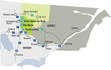
5. How to get to Témiscamingue?
The journey to Témiscamingue is a true road trip experience, whether by car, vanlife, or camping gear. If you are departing from the Quebec or Montreal region, you can take the road towards Ontario and arrive after a drive of approximately 8 to 10 hours.
From Montreal, take the Trans-Canada Highway and Trans-Canada Hwy towards Main St/ON-533 N in Mattawa, then continue on ON-533 N until you reach your destination.
From North Bay, take ON-63 North and QC-101 North.
From Toronto, take ON 11.
If you are leaving from Rouyn-Noranda, follow QC-391 and QC-101 S. QC-391 turns into Route 101.
It is possible to take a flight to Rouyn-Noranda or North Bay, then take the Maheux bus. CAREFUL : The schedule may not be flexible, but it is another option.
Check schedules here:
6. How can we get around in Témiscamingue? (travel, movement, displacement, transportation, conveyance)
The territory of Témiscamingue is vast and its attractions are spread out along its roads. It is important to come prepared with a car, RV, Winnebago, or other vehicle. Several kilometers separate the best attractions, but for some routes, it is possible to travel by bike or on foot.
The transportation options are mainly limited to personal cars, camper vans, motorcycles, and bicycles. It is also possible to rent a car in some cities in the region but not in Témiscamingue. (we are working on it !)
7. What is the population of Témiscamingue?
A population of 15,792 over an area of 20,000 km2 gives a little over 1.2km² of territory per person.
Yes, it’s a big territory. For example, The municipality of Béarn covers an area of 388.73 km²
8. What are the main economic activities in Témiscamingue?
The economy of Témiscamingue is mainly based on the exploitation of natural resources, although 70% of its jobs are in commerce and services. The transformation of forest resources and agriculture are particularly practiced there.
Rayonier, formerly Tembec, is the main industry in the region. In the city of Témiscaming, it has a pulp and paper mill. In addition, Rayonier owns a sawmill in the municipality of Béarn. Some are also located in Abitibi, as well as around the world. The fertile lands around Lake Témiscamingue make it one of the main agricultural regions in western Quebec. The dairy industry is the most present agri-food industry with several dairy farms as well as a milk processing plant, Lactalis, in Laverlochère-Angliers. Nearly 20 companies are certified organic in Témiscamingue, a production that is also gaining importance in the region.
9. Is it possible to swim in Témiscamingue? What is the water temperature like?
Yes, several public beaches are available for swimming.
Ville-Marie
7, rue Sainte-Anne Ouest, Ville-Marie (Québec) J9V 1B6
Belleterre
On the Chemin du Lac aux Sables and
424 Chemin du Lac aux Sables, Belleterre, QC J0Z 1L0
Duhamel Ouest – La Bannik
862, chemin du Vieux-Fort, Duhamel-Ouest, Québec, J9V 1N7
The water temperature varies in Lake Témiscamingue and the surrounding lakes (Lake Kipawa, Lake des Bois, Lake aux Brochets, Lake Rémigny, etc.). The smaller the lake, the warmer the temperature.
In summer, Lake Témiscamingue (big one) is around 21.8°C and above.
10. What is the climat Témiscamingue ?
Témiscamingue has what is called a microclimate. Thanks to Lake Témiscamingue, a bulge of the Outaouais River that stretches 110 km, this tempers the climate and makes it fairly warm and humid. This makes it comparable to that of Quebec City.
Winters are cold and dry (averaging -15°C) and summers are warm and humid (averaging +18°C).
The majority of precipitation falls as rain (76%) between the months of June and September, during the growing season for vegetation.
11. Ho do I get there by car?
From Montreal, take Highway 40, then Highway 417 to Ottawa, and finally Highway 17 to Mattawa. Highway 533 takes over until the gates of Témiscaming (600 km). Ville-Marie is 90 km further north. Count an hour and a half longer if you go through Abitibi (by Vérendrye parc) .
If you enter Ville-Marie in your GPS, make sure to write Ville-Marie, Quebec and not Ville-Marie, Montreal.
12. The unique elements of the region.
The only traffic light is located in Ville-Marie.
You are a 10-minute walk away from a hiking trail or a body of water for fishing
You can hear sometimes…absolutely nothing
There are NO parking meters throughout the entire territory. Never any parking fees to pay.
The Opémican National Park is one of the newest additions to the SÉPAQ, which makes it very modern.
The Obadjiwan-Fort-Témiscamingue National Historic Site showcases an ancient trading post with indigenous traces dating back 6000 years.
On Sundays, the majority of businesses are closed. It’s a day of rest for the residents.
An old forced pipeline circuit, formerly connected to the pulp and paper mill, is now a unique hiking trail.
A hidden museum, impossible to find in tourist brochures:
Musée Reva : biggest secret place in Témiscamingue (french only)